 |   | | |
 | |||
 | |||
 |
Welcome To Semsons Blog
Friday, June 6, 2008
  Mainnav MG-950D is a weatherproof, sports bluetooth GPS data logger with LCD screen that is similar to the Garmin Edge 305. However, the Mainnav MG-950D is also a bluetooth GPS receiver that can wirelessly share GPS data with other devices such as your PDA, smartphone, or laptop. Useful for hiking, biking, driving, and even running, the back-lit LCD screen displays all the important information such as altitude, current speed, maximum speed, average speed, moved distance, trip time, and total mileage (or kilometer). This Mainnav data logger uses a SiRF Star III chipset, provides up to 17.5 hours of operating time on a fully charged Li-Ion battery, and the included software can geotag photos along with the recorded tracks for display via Google Earth. The Mainnav MG-950D is convenient because it has dual bluetooth and USB interface; plus, the package includes everything from chargers to a bike mount. And if that doesn’t get you jumping for joy, Semsons & Co. Inc. is offering free US ground shipping and an additional 10% off your purchase! (Use coupon code “MG950D” at checkout.) No, we haven’t gone crazy – just hurry and place your order today because this promotion won’t last forever! Labels: biking, Bluetooth GPS, Data Logger, driving, Google Earth, hiking, LCD screen, Mainnav, running, Semsons, SiRF Star III, sport, weatherproof by: Semsons 0 Comments  
Tuesday, April 29, 2008
 Sharing photos online has long been a popular practice and is utilized by many users on the web. Thanks to the advancement of technology, the Amod AGL3080 GPS Data Logger takes photo sharing to a whole new level. When you take a digital picture, your camera records the date it is taken, but it’s up to you to remember where the picture was taken. This memory game can be a real pain if you were to go on a road trip or backpacking through someplace you’ve never been before. But with an Amod AGL3080 GPS Data Logger, it can record the place where the photo was taken and geotag it to allow you to see the location of the picture on Google Map or other online maps (a photo tagging software—Windows and Mac compatible—is included). Sharing photos online has long been a popular practice and is utilized by many users on the web. Thanks to the advancement of technology, the Amod AGL3080 GPS Data Logger takes photo sharing to a whole new level. When you take a digital picture, your camera records the date it is taken, but it’s up to you to remember where the picture was taken. This memory game can be a real pain if you were to go on a road trip or backpacking through someplace you’ve never been before. But with an Amod AGL3080 GPS Data Logger, it can record the place where the photo was taken and geotag it to allow you to see the location of the picture on Google Map or other online maps (a photo tagging software—Windows and Mac compatible—is included). The Amod doesn’t need drivers to operate because once plugged into the USB port, it appears as an external drive. Built using SiRF III chipset, this GPS data logger offers the best sensitivity and low speed tracking. The 128MB storage allows over 70 hours of continuous log (or 256,000 data records), and with 3 AAA batteries, the Amod AGL3080 can run for over 15 hours. As for system compatibility, this user-friendly data logger works with Windows, Mac, or Linux based computers. For help on geotagging pictures, visit “How to use Amod AGL3080 with MacBook”. Labels: AAA battery, Amod, Data Logger, geotag, Google Earth, Google Map, GPS, Mac, SiRF Star III by: Semsons 2 Comments
Friday, February 9, 2007
 i.Trek Z1 Solar Bluetooth Data Logger is the Swiss Army Knife of GPS combining all the latest technology into a compact unit. With 8MB on-board memory, it can record 50,000 way points according to time, distance, and speed. The recorded data can be managed by user friendly software and display the track on Google Earth for viewing and analysis. The dual power (solar cell + battery) can provide more than 100 hours in full operation or permanently ready in standby mode. This data logger is small and robust, ideal for applications such as navigation, road tracking, mountain climbing or fleet management. i.Trek Z1 Solar Bluetooth Data Logger is the Swiss Army Knife of GPS combining all the latest technology into a compact unit. With 8MB on-board memory, it can record 50,000 way points according to time, distance, and speed. The recorded data can be managed by user friendly software and display the track on Google Earth for viewing and analysis. The dual power (solar cell + battery) can provide more than 100 hours in full operation or permanently ready in standby mode. This data logger is small and robust, ideal for applications such as navigation, road tracking, mountain climbing or fleet management.Labels: battery, Bluetooth GPS, Data Logger, fleet management, Google Earth, i.Trek, mountain climb, navigation, road track, Solar, z1 by: Semsons 1 Comments
Monday, November 20, 2006
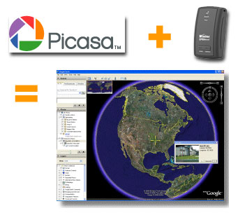 If you own a GPS data logger and a digital camera, you can have more fun with your photos by display them on Google Earth. How to do this? This is done by writing the latitude, longitude, altitude and photo direction to the image's EXIF headers to permanently embed the location data within the actual image (geotag). Google's Picasa V2.5 now includes geotag function to combine your photos with recorded tracks from your data logger and display both on Google Earth at the same time. If you own a GPS data logger and a digital camera, you can have more fun with your photos by display them on Google Earth. How to do this? This is done by writing the latitude, longitude, altitude and photo direction to the image's EXIF headers to permanently embed the location data within the actual image (geotag). Google's Picasa V2.5 now includes geotag function to combine your photos with recorded tracks from your data logger and display both on Google Earth at the same time. Labels: Data Logger, digital cameras, geotag, Google Earth, Google Map, GPS, Photo, Picasa, Semsons, Tips by: Semsons 0 Comments
Friday, November 17, 2006
 Many of you may own a GPS data logger such as RoyalTek RBT-1100, RBT-3000, or Garmin handheld. However, you can only view recorded tracks with software provided by the manufacturer. With LOGConv by Benoît, you can now convert your tracks and dispay them on Google Earth with real satellite images. Both Windows and Pocket PC are supported. Many of you may own a GPS data logger such as RoyalTek RBT-1100, RBT-3000, or Garmin handheld. However, you can only view recorded tracks with software provided by the manufacturer. With LOGConv by Benoît, you can now convert your tracks and dispay them on Google Earth with real satellite images. Both Windows and Pocket PC are supported. Labels: benoit, Data Logger, garmin handheld, Google Earth, GPS, Logconv, rbt-1100, rbt-3000, royaltek, Semsons, Software, Tips by: Semsons 0 Comments
|
Previous Posts
Archives
|

| Copyright 2007 Semsons.com All rights reserved. |
Home |
