 |  | | |
| | |||
| | |||
| |
Semsons Posting Page
Monday, November 20, 2006
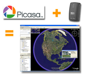 If you own a GPS data logger and a digital camera, you can have more fun with your photos by display them on Google Earth. How to do this? This is done by writing the latitude, longitude, altitude and photo direction to the image's EXIF headers to permanently embed the location data within the actual image (geotag). Google's Picasa V2.5 now includes geotag function to combine your photos with recorded tracks from your data logger and display both on Google Earth at the same time. If you own a GPS data logger and a digital camera, you can have more fun with your photos by display them on Google Earth. How to do this? This is done by writing the latitude, longitude, altitude and photo direction to the image's EXIF headers to permanently embed the location data within the actual image (geotag). Google's Picasa V2.5 now includes geotag function to combine your photos with recorded tracks from your data logger and display both on Google Earth at the same time. Labels: Data Logger, digital cameras, geotag, Google Earth, Google Map, GPS, Photo, Picasa, Semsons, Tips by: Semsons |
Previous Posts
Archives
|
| Copyright 2007 Semsons.com All rights reserved. |
Home |
0 Comments:
Post a Comment
Subscribe to Post Comments [Atom]